Product Overview
Summary
|
|
|
|
|
|
|
|
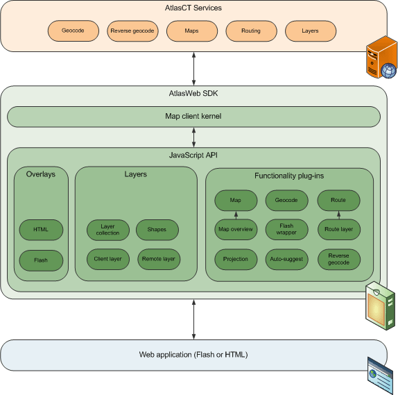
The AtlasWeb SDK is a rich development package designed for web developers; it is a client side, JavaScript based, set of routines which implement a large variety of GIS and mapping capabilities.
|
|
|
The AtlasWeb SDK architecture utilizes client-server architecture for Internet-based GIS applications.
|
|
|
The AtlasWeb SDK package includes in addition to the API function sets, built-in user capabilities which enable on-map drawing, customer layers display on the map, advanced user graphic interface and more.
|
|
|
|
|
|
The web developer utilizes the AtlasWeb SDK function sets to build his application on customer side by using the various package functions in his code.
|
|
|
When a user, on client side, enters the mapping application web page, its browser communicates with the application server, on customer side, in response the application sever downloads the application source code which contains also the include line defined by AtlasCT.
|
Introduction
The AtlasWeb SDK is a rich development package designed for web developers; it is a client side, JavaScript based, set of routines which implement a large variety of GIS and mapping capabilities.
By using the AtlasWeb SDK a web developer can easily embed an interactive map component into the web pages and add rich functionality to the map such as address searching, routes, remote layers, custom layers (mashups) and more.
The AtlasWeb SDK includes an HTTP and XML interface to the AtlasNET™ mapping server which abstracts these transactions for the developer.
The AtlasWeb SDK offers high flexibility in deploying web applications. It significantly reduces the integration and development time. The developer assists by an online documentation rich in explanations and examples. Using this package, application developing is easy and fast. Developers can use the AtlasWeb SDK in order to build special applications according to their organization requirements.
Product Architecture
The AtlasWeb SDK architecture utilizes client-server architecture for Internet-based GIS applications. It includes an API to access online the AtlasNET™ map server. The API consists of function sets which are taking care on the various tasks required to provide mapping services. Among these tasks are Geo-Coding, Routing, Map Navigation (zooming, panning), Layers management and more.
The AtlasWeb SDK function sets are divided to client side and server side function sets. The client side function sets include Map navigation and Client side Layers management. The server side function sets include Geocode management, Route management and Server side Layers management. In addition it includes a Map Client Interface for mediating with various platforms of the Map Client.
Due to the modular structure of the AtlasWeb SDK function sets, addition or removal of function sets is simple, enabling full customization of the AtlasWeb SDK for each customer according to his application requirements. The AtlasWeb SDK offers high security of customer information thanks to a verification process which is performed each time before it is downloaded to user’s computer.
The Map Client performs all the tasks between the map server and the client via the AtlasWeb SDK which mediate and manage it. The Map Client can be implemented in JavaScript or any other environment which can interact with the JavaScript based SDK.
The AtlasWeb SDK enables the developer complete access to user’s events resulting in full interactive control on map activities by the user. The AtlasWeb SDK can interface different types of databases stored on customer side for displaying internal data of the organization on maps. The internal data can be manipulated into different layers of information to distinguish how data relates.
Product Functionality
The AtlasWeb SDK package includes in addition to the API function sets, built-in user capabilities which enable on-map drawing, customer layers display on the map, advanced user graphic interface and more. The AtlasWeb SDK rich function sets enables control on each map or user event. It includes the following function sets:
Client Side
- Map navigation - it manages navigation commands such as zoom, pan, drag, etc. and enables settings of the map location and scale parameters for a specific session.
- Client side Layers management - managing layers of icons, polylines and polygons for each session. It also features integration with internal data of customer organization, disregarding the database format.
Server Side
- Geocode management - geocoding and reverse geocoding functionality managing by interacting with the map server.
- Route management - routing functionality is also provided by interacting with the map server. It includes configuration of many parameters influencing the final route resulting in a variety of routing options.
- Server side Layers management - managing layers of icons, polylines and polygons for each session in the way similar to client side layers.
Interface
- Map Client Interface - it interfaces between the Map Client and the AtlasWeb SDK.
The AtlasWeb SDK built-in user capabilities are important since they reduce the number of communications between the map sever and the client, saving time, improving security and getting better application performance. It includes the following user capabilities.
- On-map drawing; enables sketching of lines and predefined shapes (polygons, polylines and circles). Styles and colors can be defined and modified including transparency of shapes. The drawing capability is useful for various purposes.
- Icons display over the map; enables adding graphic icons, adding text labels and “mouse over” text hints to each icon and more.
- Information Windows; enables displaying detailed information within a graphical window(s) over the map. Each information window can include texts, links, Images, movies and more. This capability is implemented differently upon Map Client implementation platform.
- Geofencing is a type of proximity search and enables the user to find POI within a defined graphical area. It is done by drawing shapes by the user on every requested place on the map.
The location, shape and the style of the shapes can be modified.
Main Features
General
- Modular architecture - enables full customization and addition of new modules.
- Rich map and user functionality.
- Online documentation including examples.
- Full security of customer’s registration information.
- Textual interface using XML.
- Ease of use.
Mapping capabilities
- API to a map server.
- Additional API functions - Client side drawing and editing tools.
- Full Geo-Coding and Reverse Geo-Coding support.
- Enhanced Routing support - options such as “quickest”, “shortest” and more.
- Geo-Fencing mechanism on client and server layers.
- Map functionality - zooming, panning, and dragging functions.
Rich user events
- Map modify events.
- Map Mouse events.
- Shapes Mouse events
- Map tools events.
Multi platform support
- Interface to maps in various formats - vector (SWF, SVG), raster (GIF, BMP, WBMP, and JPEG).
- Support common browsers - Microsoft Internet Explorer®, Firefox®, Opera™, Safari™, Chrome™ and more.
- Support various client formats - JavaScript, and Java.
- Increased support for different browser character set and specific languages.
Data manipulation
- Data manipulation tools on client side.
- Display different icons for different information layers.
- Layers management on client side.
- Shapes manipulation of client side layers.
User Interface
- Map skins and toolbars style full customization.
- On map forms support (dialogs and information bubbles).
- Displayed map size can be changed on run-time.
Application Development
The web developer utilizes the AtlasWeb SDK function sets to build his application on customer side by using the various package functions in his code. Map skins and toolbars used in web page design, are another part of the application building which are either designed by the developer or supplied by AtlasCT. The developer has to insert into the web page code an include line defined by AtlasCT which is also used for identification and activation purpose. In addition the include line defines the required function sets the developer whishes to use.
The AtlasWeb SDK is customized according to the specific application of each customer. This way the included script always stays compact and contains only the applicable function sets. Downloading a compact AtlasWeb SDK package, for application activation purpose, results in shorter download time and quicker application upload.
The online AtlasWeb SDK manual assists the developer during the development process. It includes detailed explanation of the functions, methods and events as well as code examples for easy and quick application building.
Product Communication
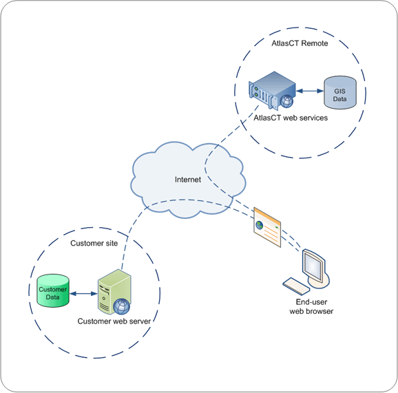
When a user, on client side, enters the mapping application web page, its browser communicates with the application server, on customer side, in response the application sever downloads the application source code which contains also the include line defined by AtlasCT. The user’s browser follows the include line instructions and communicates with the Management sever, on AtlasCT side. A verification process begins in which the customer account is checked against the website domain responsible for the request. After the verification process is completed successfully the Management server generates an AtlasWeb SDK code package according to customer settings. The customized AtlasWeb SDK together with the Map Client are downloaded to the user’s computer. The communication between the Management server and user’s browser is done only once at the begging of each session. The Map Client, now on client side, communicates with the AtlasNET™ map server, which provides the required map to the user’s computer. The user can now start using the map. The session terminates when the web page is closed by the user.
The Map Client is responsible for getting the map files from the AtlasNET™ map server, and is also responsible for passing the events from the user to the various function sets of the AtlasWeb SDK. When the Map Client is implemented as pure JavaScript and HTML5, it can run on any platform, resulting in improved speed, high visualization and better availability. The AtlasWeb SDK performs tasks specified by the application, part of them requires connection with the map server and part of them are performed locally, on client side.
All transactions between the map server and the AtlasWeb SDK are transparent to the user.
|